Baligasm
Baligasm

Destination guide · Highlands

Kintamani Area Guide

A live volcano, a crater lake and cold, clear dawns, an hour above Ubud.

By the Baligasm editors · Updated 29 October 2026

Area brief

What Kintamani is really like

Kintamani is the Bangli highland district wrapped around Mount Batur, a 1,717 m active volcano standing in a caldera roughly 10 by 13 km across, with Lake Batur along its eastern side. The airport is about 70 km away, a 2 to 2.5-hour drive, and Ubud an hour. It suits early risers after the sunrise climb, hot springs and rim views. One long day from Ubud works; two or three nights let you slow down.

To most visitors, Kintamani is less a town than a landscape: the rim and floor of the Batur caldera, a vast bowl formed when the ground collapsed twice, around 29,000 and 20,000 years ago. From that floor Mount Batur climbs some 700 m, and its most recent eruption was in 2000. Lake Batur covers about 16 square km of the south-east side and reaches 88 m at its deepest. The rim road runs at roughly 1,450 m, which is why evenings here call for a fleece rather than a sarong.

The usual visit is a single compressed morning. Vans collect climbers in Ubud around 2 am, and by 6 several hundred people are standing on the summit; guides put daily numbers at 400 to 500 before a dip in 2023. Cold air, dust and a slow line of headlamps on the final ridge come with the package. When the sky is clear, though, the sun rising beside Mount Abang and Mount Agung still earns the lost sleep.

The area is rougher round the edges than Ubud. Foreign adults pay IDR 50,000 at a road retribution post just to enter, sellers work every viewpoint, and boatmen at Kedisan open high for the Trunyan crossing. Sand quarries in the lava fields put heavy trucks on caldera roads, while fish farms and farm runoff have fouled the lake, so nobody swims in it. Compared with Ubud, an hour south, there are far fewer places to eat and sleep; compared with Bedugul, the other cool lake district, Kintamani is wilder and built around one big climb.

It is also among the holiest landscapes in Bali. Balinese regard Lake Batur as the source of every spring and river on the island, and Pura Ulun Danu Batur, the supreme water temple, sits on the rim above it. Both belong to the subak irrigation system that UNESCO listed in 2012, the same year the caldera became a UNESCO Global Geopark. Coffee is the other local pride: in 2008 Kintamani arabica became the first Indonesian product granted a geographical indication.

Best for
Sunrise climb, caldera views, hot springs and highland coffee
Vibe
Cold, volcanic and raw; crowded at dawn, quiet by afternoon
From the airport
About 70 km, a 2 to 2.5-hour drive
Days needed
One long day from Ubud; two or three nights to slow down
Best time
June to September for clear dawns; early mornings all year
Getting around
Car and driver; jeeps on the lava tracks

Kintamani suits you if…

  • ✓A guided climb up an active volcano at dawn, with no technical skill needed
  • ✓Wide views over the caldera, Lake Batur, Mount Abang and Mount Agung
  • ✓A hot spring soak on the lakeshore after a cold summit
  • ✓Coffee lovers: Kintamani arabica carries protected origin status
  • ✓A scenic route over the mountains to Lovina and the north coast

Skip it if…

  • ✕Early alarms ruin your trip: from the south, trek pickups come at 1 to 2 am
  • ✕You hoped for a peaceful summit; hundreds share it on most mornings
  • ✕Cold and damp get you down; nights on the rim fall to about 14–17°C
  • ✕Persistent sellers wear you out: expect hawkers, a road fee post and boat haggling
  • ✕You want to swim in the lake: it is farmed and polluted, so use the hot springs instead

Neighbourhoods

Which part of Kintamani to stay in

01

Penelokan and the caldera rim

Penelokan is the southern section of the rim road, the point where the whole caldera suddenly spreads out below you. Along this strip are the Batur Geopark Museum, a retribution post, the pasah-day dawn market and a line of cafés with terraces facing the volcano. Tour coaches pull in for lunch, so it is busy at midday and quiet at night. Rooms with a view are easy to find, but the lake villages are a 10 to 20-minute drive down the hairpins.

Best for: A night or two with the caldera in front of you, touring by car

02

Kintamani town and Batur

Batur and Kintamani village line the western rim at roughly 1,450 m, a few kilometres north of Penelokan. The village moved up here, together with Pura Ulun Danu Batur, after lava from the 1926 eruption buried the original settlement on the caldera floor. Today it is a working highland town of temples, a morning market and coffee gardens rather than a resort. The main road carries on north past Penulisan to Singaraja.

Best for: Temple visits and a working highland town

03

Toya Bungkah and the west shore

Toya Bungkah sits on the lakeshore right under the volcano, about 8 km and 20 minutes below Penelokan. The trekking guides' association has its office in the village, most climbs begin from the car park on its edge, and two hot spring complexes look out over the water. A homestay here means a 3:30 am meeting with your guide instead of a 2 am van from Ubud. Evenings are quiet and dinner options are limited.

Best for: Climbers who want to sleep a few minutes from the trailhead

04

Kedisan, Buahan and the east shore

Kedisan is where the hairpin road from Penelokan reaches the lake, roughly 3.5 km and 10 minutes down. Its jetty is the departure point for boats to the Trunyan cemetery, and warungs by the water cook tilapia from the lake farms, often as mujair nyat-nyat, braised in a spice paste. A narrow lane follows the eastern shore through Buahan towards Trunyan village, with the volcano across the water the whole way.

Best for: Boat trips to Trunyan and a lakeside tilapia lunch

05

Songan and the north-east shore

Songan stretches along the north-eastern shore, 5 to 6 km beyond Toya Bungkah, where the road stops beneath the outer caldera wall. Vegetable plots slope down to the water and campsites look straight across at Mount Batur. It is the calmest place to spend a night in the caldera, with clear stars once the day-trippers have gone, but shops are basic and the nights are damp.

Best for: Campers after the volcano view without rim traffic

06

Pinggan and the north rim

On the northern rim, Pinggan and Sukawana lie 14 to 16 km by road from Penelokan. The roadside lookouts at Pinggan are where non-hikers come for sunrise, watching mist settle in the caldera below Batur, Abang and Agung. Sukawana is home to Pura Puncak Penulisan, often described as the highest temple in Bali. Both are farming villages with very little accommodation.

Best for: Sunrise without the climb, and road trips to the north coast

Top sights · 16 picks

Things to do in Kintamani

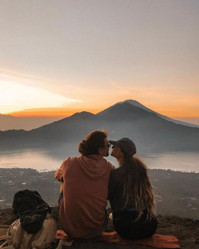
Mount Batur sunrise trek
Photo by @imaginhogangrey

01 · Adventure

Mount Batur sunrise trek

📍 Toya Bungkah trailhead, west shore of Lake Batur, 8 km below Penelokan

This is the climb most visitors come for. Groups set off with a local guide from Toya Bungkah at around 4 am and gain 500 to 650 m on loose volcanic grit, reaching the 1,717 m summit in roughly two hours. Depending on the month, the sun appears between about 5:50 am (November) and 6:30 am (July), lighting the lake, Mount Abang and Mount Agung. Strong walkers can ask for the crater route, about 500 m of extra rim walking past steaming vents.

Tip: Private treks with pickup, guide and fees run IDR 300,000–700,000 a person, depending on group size.

02 · Viewpoint

Penelokan caldera viewpoint

📍 Penelokan rim road, southern caldera rim

Kintamani's finest view asks for no effort at all. Stand on the rim road at Penelokan and the entire caldera fits in one frame: the cone of Batur, dark streaks of old lava, the curve of the lake and the far wall climbing towards Mount Abang. Visibility is best in the morning; by early afternoon cloud often pours into the bowl and the volcano disappears. Cafés along the road serve coffee with the same outlook, and sellers approach as soon as you step out of the car.

Tip: Foreign adults pay a IDR 50,000 area fee at road posts, 8 am–5 pm. A polite, firm no works with hawkers.

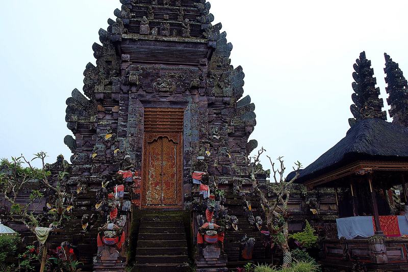
Pura Ulun Danu Batur
Photo: Saranabhi / Wikimedia Commons (CC BY-SA 3.0)

03 · Temple

Pura Ulun Danu Batur

📍 Batur, on the main road 5 km north of Penelokan

Ranked second only to Besakih, this is the supreme water temple of Bali, the shrine tied to the lake that farmers believe feeds the island's springs. It once stood at the foot of the volcano; the eruption of August 1926 buried the village and left only its 11-tiered meru standing, so the temple was rebuilt up on the rim. Nine temples now hold 285 shrines and pavilions, often wrapped in mist, and the complex sits within the 2012 UNESCO subak listing.

Tip: Small entry fee with a sarong included. Its biggest festival comes with the tenth Balinese full moon, often late March or April.

04 · Wellness

Hot springs at Toya Bungkah

📍 Toya Bungkah, west shore of Lake Batur

Coming down off a cold summit, an hour in warm volcanic water is hard to beat. Batur Natural Hot Spring, run by the village, has pools at several temperatures, one for children and a restaurant on the lakeshore. Toya Devasya, a short way along the shore, is larger, with eight natural pools and a big swimming pool. Both get crowded from mid-morning as trek groups come down, so head there straight from the trail.

Tip: Batur Natural Hot Spring: foreign adults IDR 200,000 with towel and locker, open 7 am–7 pm.

05 · Viewpoint

Pinggan sunrise viewpoint

📍 Pinggan village, northern caldera rim, 16 km from Penelokan

Pinggan gives you the sunrise without the climb. On a good dry-season morning, mist settles in the caldera while Batur, Abang and Agung rise above it in layers, lit from behind. Roadside spots go quickly, so arrive by 5:30 am. The village is 16 km from Penelokan on the northern rim, which means coming with a driver or on a jeep tour rather than riding a scooter in the dark.

Tip: Wet-season cloud can hide everything. Bring small cash for parking.

06 · Nature

Black lava fields

📍 Lower slopes of Mount Batur

Batur's lower slopes are still coated in sharp black rock from the eruptions of 1849, 1926, 1963–64, 1968 and 1974, with ferns and young pines only slowly taking root. The largest flow, from 1963–64, is the dark scar you can pick out from anywhere on the rim. Jeep tours and the climb both cross parts of it. Some of the fields are now quarried for building sand, so be ready for trucks, dust and noise on the access tracks.

Tip: Closed shoes only; the rock is sharp and loose.

07 · Adventure

Sunrise jeep tour

📍 Lower slopes of Mount Batur, starting from Toya Bungkah

For anyone who will not or cannot climb, 4WD jeeps grind up dirt tracks to a lookout far below the summit, then roll out across the lava fields, often finishing at a hot spring. It is loud and dusty, and dozens of other jeeps share the lookout, but it works for families, older travellers and bad knees. Hotel pickups run from about 1:30 to 3 am, depending on where you are staying.

Tip: A private jeep for two with fees and breakfast costs around IDR 1,350,000.

08 · Temple

Pura Puncak Penulisan

📍 Sukawana, 12 km north of Penelokan on the Singaraja road

Also known as Pura Tegeh Koripan, this temple stands at 1,745 m in Sukawana and is often said to be the highest in Bali. Around 300 steps lead through pines up seven terraces to pavilions sheltering ancient stone statues; one inscription names King Udayana, who ruled Bali in the 10th century. Few tour groups make the detour, so the climb is usually quiet and often cold, with cloud drifting across the terraces.

Tip: Ticketed by Bangli regency. Sarong and sash required; take the stairs slowly at this altitude.

Show all 16 things to do ↓

09 · Food & Drink

Breakfast on the caldera rim

📍 Penelokan rim road, southern rim

The cafés lining the Penelokan rim sell breakfast with the volcano across the caldera as a backdrop. Kintamani Coffee by Akasa has volcano-facing terraces and opens at 6 am, and Blue Mountain Cafe offers a set sunrise breakfast. Prices sit close to Ubud levels, around IDR 175,000 to 250,000 a person. It makes a good plan for non-hikers, and a pleasant finish for climbers who skipped breakfast on the summit.

Tip: Weekend mornings are the busiest; aim for a weekday before 8 am.

10 · Culture

Batur Geopark Museum

📍 Penelokan rim road, Penelokan

Opened after the caldera joined UNESCO's Global Geoparks Network in 2012, this rim-top museum makes sense of the scenery outside. Dioramas and a large relief model show how Bali emerged from undersea volcanoes and how Batur's caldera collapsed, and binoculars on the upstairs deck point straight at the crater. It is a useful stop before or after the climb, and a dry option on a cloudy day. Plan on about an hour.

Tip: Around IDR 20,000 for adults. Closed on Fridays and public holidays.

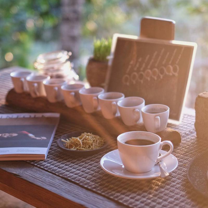
Kintamani arabica and coffee farms
Photo by @kalvin.ping

11 · Food & Drink

Kintamani arabica and coffee farms

📍 Farms along the rim road and north of Kintamani town

Grown on volcanic slopes and known for a bright citrus note, Kintamani arabica became the first Indonesian product with a protected geographical indication, in 2008. Many tours stop at a plantation shop with a free tasting tray. Be wary of kopi luwak, the so-called civet coffee: undercover reports have shown the animals caged in cramped conditions to make it. Look instead for a farm or café that names its growers and sells arabica by origin.

Tip: If a stop shows caged civets, buy nothing labelled luwak.

12 · Adventure

Downhill cycling to Ubud

📍 From Penelokan down towards Ubud, with hotel pickup

This is Kintamani without a 2 am alarm. After breakfast on the rim, you freewheel down quiet back roads through villages, temples and rice fields towards Ubud, with a support van following behind. Bali Eco Cycling has run the route since 1999; the full outing takes 8 to 10 hours with lunch and is gentle enough for families with children who ride confidently.

Tip: Adults IDR 900,000, children aged 5–12 IDR 750,000, pickup included.

13 · Nature

Lakeside camping in Songan

📍 Songan, north-east shore of Lake Batur

Spending a night on the caldera floor changes how Kintamani feels. Camps and glamping sites in Songan, including Bobocabin Kintamani and Sunrise Hill Camp, look straight across the water at Mount Batur. Once the day visitors leave you get a sky full of stars, and in the morning the sun comes up over the lake in front of your tent. Nights are cold and damp, so pack warm layers.

Tip: Book ahead for weekends; from December to March fog and rain are common.

14 · Nature

Mount Abang hike

📍 Suter, eastern caldera rim

Mount Abang, at 2,151 m, is the highest point of the caldera rim and the quiet counterpart to Batur. From Suter the trail rises through forest past small shrines, taking about two hours up and 90 minutes back down. The trees hide much of the view, but you may have the path entirely to yourself. There is nowhere to buy water on the way, so carry everything you need.

Tip: Register in Suter and take a local guide.

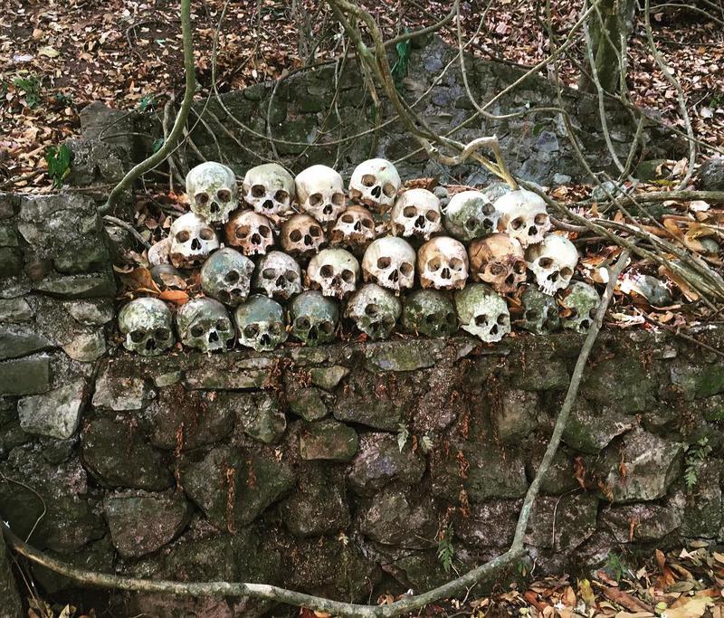
Trunyan village and cemetery
Photo by @p_lou

15 · Culture

Trunyan village and cemetery

📍 East shore of Lake Batur; boats from the Kedisan jetty

Trunyan is a Bali Aga village on the far shore whose people neither cremate nor bury all of their dead. Married villagers who died of natural causes are laid out under bamboo cages beside a Taru Menyan tree, whose scent locals say masks any smell. The boat from Kedisan takes 15 to 30 minutes. Boats are priced per trip rather than per person, and expect requests for donations once you land.

Tip: Fix one price for boat, entry, guide and donation before boarding; a six-seat boat runs about IDR 550,000, entry extra.

16 · Market & Shopping

Pasar Penelokan dawn market

📍 Behind Pasar Seni Geopark Batur, Penelokan

Once every three days, on pasah in the Balinese calendar, a local market fills a pine clearing behind the Pasar Seni Geopark Batur building. Villagers start arriving around 4 am to trade vegetables, chickens, lake fish, pork, cakes and everything needed for offerings. Nothing here is aimed at visitors, which is exactly why it is worth an early detour on the way to or from the trailhead.

Tip: Ask your host which day is pasah and arrive before 7 am.

Itinerary

How to spend your days in Kintamani

Kintamani in a day

A trek day from Ubud with a hired driver. You walk 6 to 10 km, all of it on the volcano; everything else, around 100 km in total, is by car.

  1. 2:00

    Your driver collects you in Ubud for the 44 km run north to Toya Bungkah; with the briefing, allow about 1.5 hours.

  2. 4:00

    Start climbing with your guide; the summit is roughly two hours away.

  3. 6:00

    Watch the sunrise and eat a breakfast cooked in the steam vents, then descend to reach the car park by about 8:30.

  4. 9:00

    Soak at one of the Toya Bungkah hot springs, a few minutes' drive from the trailhead.

  5. 11:00

    Drive 8 km (20 minutes) up the hairpins to Penelokan for the rim view and the Geopark museum, which is shut on Fridays.

  6. 12:30

    Lunch on the rim, then head 5 km north to Pura Ulun Danu Batur.

  7. 14:30

    Drive back to Ubud in about an hour, stopping at Tirta Empul if you still have the energy.

Three days around the caldera

Two nights by the lake in Toya Bungkah or Songan. Use a driver on the first and last days; the middle day is the climb plus short hops around the shore.

  1. Day 1, 11:00

    Leave Ubud, visit Tirta Empul on the way up, then stop at the Geopark museum in Penelokan.

  2. Day 1, 14:00

    See Pura Ulun Danu Batur, then wind down the hairpins to your lakeside room.

  3. Day 2, 4:00

    Climb for sunrise, adding the crater route if your legs allow.

  4. Day 2, 10:00

    Hot springs, then lake tilapia for lunch at a warung in Kedisan.

  5. Day 2, 14:00

    Cross to Trunyan once the full price is agreed, or rest at camp.

  6. Day 3, 5:30

    Sunrise from Pinggan, then 11 km (about 25 minutes) to Pura Puncak Penulisan.

  7. Day 3, 9:00

    Coffee on the rim, then continue north to Lovina (1.5–2 hours) or back south to Ubud.

Kintamani on a cloudy or rainy day

When cloud fills the caldera, drop the sunrise and build the day around the museum, the temple and warm water.

  1. 8:00

    Leave Ubud after the trekkers have gone and check the forecast for the rim on the way up.

  2. 9:30

    Batur Geopark Museum in Penelokan (not on Fridays) for the relief model and the crater deck.

  3. 11:00

    Pura Ulun Danu Batur, 5 km north; mist drifting through the courtyards suits the place.

  4. 12:30

    Lunch at a rim café, or a hot bowl of soup in Kintamani town.

  5. 14:00

    Drive down to Toya Bungkah for a long soak; the hot springs stay open in the rain until 7 pm.

  6. 16:30

    Head back to Ubud before dark, as fog on the hairpins makes night driving slow.

Longer trip? Plan up to seven days from Kintamani or browse our Bali itineraries.

Seasons

Best time to visit Kintamani

Expect cooler, wetter weather than on the coast. Nights on the rim drop to about 14–17°C, and the summit before dawn is colder still, with wind. Monthly rainfall swings from roughly 65 mm in August to over 400 mm in January. The driest trail and clearest sunrises come from June to September. Between December and March, cloud often blocks the view and the grit on the trail turns slippery.

In any month, cloud tends to rise out of the caldera from late morning, so visit the viewpoints early. The climb is at its most crowded in July, August and over Christmas and New Year; April, May and October are quieter compromises with slightly more cloud.

The odalan, or temple festival, at Pura Ulun Danu Batur is timed to the tenth Balinese full moon, which normally lands in late March or April. Nyepi, Bali's day of silence, is on 8 March 2027; nobody leaves home for 24 hours, so there are no treks that day.

Getting there

How to get to Kintamani

  • Ngurah Rai airport (DPS)2–2.5 hours

    A 70 km drive. Public transport is no help here, so book a driver in advance.

  • Ubud60–75 minutes

    Trek vans leave Ubud around 2 am for the 37 km drive north through Tegallalang.

  • Seminyak, Canggu or Kuta2–2.5 hours

    Vans for the climb collect you around 1:15 am for the 66 km run, so a night in Ubud first makes sense.

  • Sanur1.5–2 hours

    A 57 km drive; climbers are collected at around 1:30 am.

  • Uluwatu, Jimbaran or Nusa Dua2.5–3 hours

    Treks collect you around 1 am for a 75–90 km drive, the longest from any beach base.

  • Lovina and the north coast1.5–2 hours

    Via Singaraja and over the rim at Penulisan, roughly 65 km.

  • Besakih / Sidemen30–45 minutes / 1–1.5 hours

    Winding mountain roads, roughly 19 km to Besakih and 37 km to Sidemen.

Getting around Kintamani

Kintamani's sights are too far apart to walk between. The rim, the lake villages and the north rim sit 5 to 16 km from one another, and the road from Penelokan to Kedisan falls roughly 400 m through hairpin bends. A car and driver for the day is the simplest answer, and it also takes care of the pre-dawn trek pickup.

Avoid riding a scooter at night. Fog, unlit bends, sand trucks and cold make the 2 am run up from Ubud risky, and loose grit lies across the roads near the lava fields. Ride only if you are experienced, licensed and wearing a helmet.

Ride-hailing cars will drop you on the rim, but few drivers hang around for a fare back down, so book transport for both legs. A planned online system for the area fee was put on hold in October 2026, so carry cash for the road posts.

Know before you go

Kintamani tips that save time

  1. 01Pack for the summit: warm layers, long trousers, a beanie and a waterproof jacket.
  2. 02Wear trail shoes with real grip. Coming down the loose grit is harder than going up.
  3. 03Get the trek inclusions in writing: guide, entry fees, breakfast and pickup.
  4. 04Check Batur's alert level on MAGMA Indonesia (magma.esdm.go.id) the day before you go.
  5. 05Keep small notes for the area fee post, parking, hot springs and donations.
  6. 06See the rim viewpoints before noon; the caldera usually fills with cloud by early afternoon.
  7. 07At Kedisan and Trunyan, settle every price before you step into a boat.
  8. 08Carry a sarong and sash for Pura Ulun Danu Batur and Pura Puncak Penulisan.
  9. 09Bali's IDR 150,000 tourist levy is separate from the Kintamani area fee and from site tickets.

FAQ

Kintamani questions, answered

Is the Batur sunrise climb worth the early start?

+

On a clear morning, yes, as long as you accept company. In about two hours you reach the top of an active volcano and watch dawn break over Lake Batur and Mount Agung. The cost is a pickup between 1 and 2 am, cold air, dust and several hundred other climbers on the summit. If heavy cloud is forecast, consider Pinggan or a later visit instead.

How difficult is the Mount Batur climb?

+

Moderate. Expect around two hours of walking in the dark and 500 to 650 m of ascent on loose volcanic grit, finishing with a steep, rocky section below the summit. Anyone able to walk uphill for two hours with rest stops can manage it. Coming down is tougher on the knees than going up, so poles and grippy shoes help.

Can I climb Batur without a guide?

+

Not in practice. Climbs are organised through the Mount Batur trekking guides' association (PPPGB) in Toya Bungkah, which through the 2000s and 2010s had a reputation for pressuring independent hikers. Every tour includes one of its guides, so the sensible approach is to book an operator that lists the guide and every fee in writing.

What does a Batur trek cost?

+

A private trek including pickup, guide, fees and breakfast costs IDR 700,000 for someone climbing alone, falling to about IDR 300,000 each when five people share the guide. Pickups from Seminyak, Canggu or the Bukit cost more, and the hot springs are normally an add-on. Confirm exactly what is included before paying a deposit.

What time do Batur treks begin?

+

Guides set off at about 4 am so groups reach the top around 6. That means pickups at roughly 2 am in Ubud, 1:30 am in Sanur, 1:15 am in Seminyak, Canggu and Kuta, and 1 am in Nusa Dua or Uluwatu. Spend the night in Toya Bungkah and you can get up at 3:30 instead.

Is Kintamani worth a visit if I skip the trek?

+

Yes. None of the rim view at Penelokan, the hot springs, Pura Ulun Danu Batur or a dawn at Pinggan needs any climbing, and jeeps can take you to a sunrise spot on the volcano itself. A half day from Ubud is enough for the rim and the temple. Go in the morning, before cloud fills the caldera.

Do I have to pay to enter Kintamani?

+

Yes. Bangli regency runs fee posts on the main roads from 8 am to 5 pm. Bali residents pay IDR 10,000, other Indonesians IDR 25,000 and foreign adults IDR 50,000. It is separate from the IDR 150,000 Bali tourist levy and from individual site tickets, so keep small cash to hand.

Is it safe to climb Mount Batur?

+

Usually, yes. Batur is an active volcano whose last eruption was in 2000, so check the alert level on MAGMA Indonesia before setting out. The more common risks are mundane: a slip on sliding grit before dawn, a biting wind on the summit and the pre-dawn drive on foggy, winding mountain roads.

Can visitors see the Trunyan cemetery?

+

Yes. Boats cross from Kedisan in 15 to 30 minutes. In Trunyan, married villagers who died naturally are left beneath bamboo cages instead of being buried. This is an active burial ground, so cover up, ask permission before photographing anyone and settle a single all-in price for boat, entry and donations before you leave the jetty.

Where should I stay for the Batur climb?

+

Ubud is the usual base, an hour away, with far more hotels and restaurants. Sleeping by the lake in Toya Bungkah or Songan moves the alarm to about 3:30 am and puts the hot springs on your doorstep, though food and shopping are basic. Rooms on the Penelokan rim have the view but sit 20 minutes from the trailhead.

Nearby

Where to go after Kintamani

Read next

More Kintamani guides on the Blog