
Tabanan · Nature
Jatiluwih Rice Terraces, Tabanan
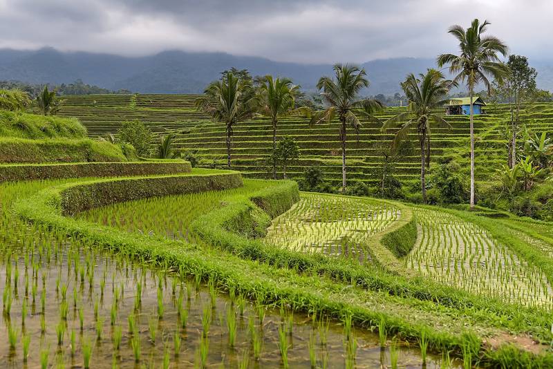
Red-rice paddies on the flank of Mount Batukaru, farmed by their subak and crossed by marked trails.
By the Baligasm editors · Updated 29 October 2026 · Photo: Jorge Franganillo / Wikimedia Commons (CC BY 2.0)
Overview
Jatiluwih Rice Terraces: before you go
Jatiluwih is a farming village in Tabanan whose terraces, roughly 700 m up on Mount Batukaru, are the most visited part of Bali's UNESCO subak landscape. The drive from Ubud or Canggu takes up to two hours, and the airport is 1.75 to 2.5 hours away. Foreign adults pay IDR 75,000. Plan two hours for a short loop or half a day for a long trail. It suits walkers; for a quick photo, Tegallalang is nearer.
Around 3,000 people live in Jatiluwih, on the southern slopes of Batukaru, the second-highest volcano in Bali. Their fields belong to the island's only World Heritage Site, inscribed in 2012 as Bali's cultural landscape of the subak, named for the way it expresses the Tri Hita Karana philosophy. That listing spans five sites and about 19,500 hectares. By far the biggest, the Catur Angga Batukaru landscape of over 17,300 hectares, includes Jatiluwih, whose terraces appear in a 10th-century inscription, according to UNESCO.
What you are really seeing is the subak at work. Each one is a farmers' cooperative drawing on a shared water source, steering it through channels and weirs and marking every stage of the crop with offerings at field shrines and water temples. UNESCO traces the system back to the 9th century and links it to Tri Hita Karana, the Balinese principle of harmony between people, nature and the gods. Seven subak here manage wet rice and an eighth looks after dry gardens, and the local red rice is still widely planted, which needs four to six months to ripen.
In practice, one road threads through the village past a ticket post and a string of eateries, and halfway along it are the viewpoint and the starts of the trails. Tour coaches generally pause long enough for a meal and a picture before driving on, so a few minutes along any trail you are largely alone. Treat it as a working farm rather than a park: the dykes are the farmers' footpaths, the shrines are active, and what you see depends on the stage of the crop. On a cloudy afternoon in the wet season, the view can disappoint.
The last two years have been turbulent. Foreigners paid IDR 40,000 until March 2024, then IDR 50,000, and IDR 75,000 by April 2025. UN Tourism listed Jatiluwih among its Best Tourism Villages in November 2024. On 2 December 2025 a provincial spatial-planning committee found 13 structures in the protected paddies, mostly field huts turned into warungs, and several were sealed. Farmers, long unhappy at how little ticket income reaches them, hung zinc and black plastic across the view, and visitor numbers fell by as much as 80 percent. On 5 January 2026, once the regency had pledged a moratorium on new building, the screens were taken down; the village festival was held again on 20 and 21 June.
- Opening hours
- Daily; ticket posts staffed from about 8 am to 6 pm
- Ticket
- Foreign adults IDR 75,000; foreign children IDR 50,000
- Time needed
- About 2 hours with one short walk; 4 hours or more with a long one
- Best time
- 7 to 10 am; April to October for firmer paths
- Dress code
- No dress code; grippy shoes, a hat and a rain layer
- Location
- Penebel district, Tabanan; roughly 45 km by road from Ubud
Jatiluwih, Penebel, Tabanan Regency, Bali 82152
Open in Google Maps ↗Read it on the Blog →What to see
What to see at Jatiluwih Rice Terraces
The main viewpoint and terrace road
The village road cuts straight across the middle of the valley, and the stretch by the main lookout and the UNESCO marker offers the postcard scene: layer upon layer of paddies filling the basin, with Batukaru's summit to the north-west. Jatiluwih Resto, J-Terrace and Warung Wayan are among the restaurants here with tables set above the fields. Before 10 am the peak is usually free of cloud and the tour vans have yet to arrive.
The marked walking loops
Loops marked by colour begin near the ticket post and the main viewpoint, all covered by your ticket. The routes have been redrawn over the years, so descriptions vary. A common version starts with a red loop of about 1.5 km, taking 30 to 45 minutes, then purple, yellow and blue circuits of between 2 and 3 km, up to a white route of roughly 5.5 km that needs three or four hours. Other accounts mention green and blue loops of 6 to 7 km. Take a photo of the map board before you go.
Walking with a farmer
With a local guide the walk becomes a lesson in farming: which channel waters which plot, why planters move backwards while bowing towards the mountain, and who the small field shrines are for. Guided treks start at around IDR 450,000, and village guides also lead longer hikes to Wongaya Gede, about 10 km off near Pura Luhur Batukaru. Settle the route, distance and fee before you start.
Planting or harvesting rice
Alongside trekking and cycling, the village tourism office sells time in the fields. You step into a flooded paddy and press seedlings into the mud by hand, or help cut rice at harvest, while a farmer explains how water is shared between neighbours. The activity depends on the month's crop; the red-rice harvest comes around June, and at the 2026 festival visitors joined in. Book two or more days ahead and dress for mud up to the knee.
E-bikes on the farm tracks
An electric bike carries you well past the walking loops, onto tracks beside irrigation channels and through the hamlets behind the terraces, with the motor doing the uphill work. Several village warungs rent bikes, including the Green Bike EV stand marked on the village map, and guides lead rides lasting an hour or two. Cycling packages start at about IDR 470,000. Cars and motorbikes are not allowed on the trekking paths.
Red rice for lunch
The restaurants along the terrace road cook the village's own red rice as nasi merah, served with Balinese dishes and sambal. Look out too for laklak, small red-rice-flour pancakes finished with palm sugar and fresh coconut, and for red-rice tea; these were the snacks Jatiluwih served to World Water Forum delegates in 2024. Choose red over white: it is the very crop you have come to see.
Dawn and a night in the village
Most visitors arrive around midday. Staying overnight swaps that for first light, with mist lying in the valley, farmers heading out to work and the paths to yourself. Families in the village let out around 70 homestay rooms, and there are also a few villas and glamping spots. Nights are cool and very quiet, and restaurants shut early, so sort out dinner before dark.
Temples among the paddies
Small temples sit in and above the fields, Pura Luhur Bhujangga Waisnawa and Pura Dalem Gunung Sari among them, together with subak shrines where offerings mark each stage of the crop. Management rules bar visitors from entering any temple or sacred spot without a guide, so look from the path unless a villager offers to accompany you, in which case put on a sarong and sash.
Seasons
Best time to visit Jatiluwih Rice Terraces
Aim to arrive between 7 and 10 am. Early on, Batukaru is normally clear, the low sun picks out each tier, and the day-trippers from the south are still on the road. The main viewpoint is at its busiest from about 10 am until 2 pm, cloud often gathers over the peak by late morning, and showers are common in the afternoon even in the dry months. Late afternoon, once the tours have moved on to Tanah Lot, quietens down again, and only a night in the village gets you onto the trails at sunrise.
The crop counts for more than the calendar, and staggered planting means you will nearly always find green somewhere. For the main red-rice crop, ploughing and flooding happen in January and February; the paddies stay vivid green through to about April, ripen to gold during May and are harvested in June, the month of the 2026 festival. After that comes a quicker crop, frequently a modern white variety, planted from around July and green again between about August and October.
April to October, the dry season, brings firmer paths and clearer views, with the least rain and the most visitors in July and August. Between November and March afternoon storms are the norm and the dykes become slippery. Heavy overnight rain in March 2024 set off a landslide inside the subak zone that destroyed a timber villa and killed two guests from abroad, so heed local warnings in the wet season. Lebaran brings Indonesian holidaymakers in large numbers; more than 2,500 came on 30 March 2025 alone. On 8 March 2027 the island-wide silence of Nyepi shuts everything.
Getting there
How to get to Jatiluwih Rice Terraces
Ubud1.5–2 hours
Roughly 45 km north-west with a driver, through Badung and up via Penebel. Pura Taman Ayun in Mengwi is a natural stop on the way.
Canggu1.5–2 hours
About 50 km north through Tabanan with a driver. Set off by 6:30 am to beat the cloud and the minibuses.
Seminyak1.75–2.5 hours
Around 50–58 km by car; how long it takes depends on morning traffic in Kerobokan and Canggu.
Ngurah Rai airport (DPS)1.75–2.5 hours
Some 55–65 km in a pre-booked car. Rather than heading up on arrival day, visit from wherever you are based, and avoid late-afternoon traffic around Canggu.
Bedugul and Lake Beratan45–60 minutes
About 25 km south-west by car through Baturiti, so the lake temple and the terraces make one cool-weather day.
Sanur1.75–2.25 hours
Roughly 50–60 km via Denpasar's ring roads; time the drive back for before 4 pm or after 7 pm.
Uluwatu2.5–3 hours
Roughly 75–80 km via the airport. Make it a whole driver day, or break the journey with a night in the regency.
| From | Time | How |
|---|---|---|
| Ubud | 1.5–2 hours | Roughly 45 km north-west with a driver, through Badung and up via Penebel. Pura Taman Ayun in Mengwi is a natural stop on the way. |
| Canggu | 1.5–2 hours | About 50 km north through Tabanan with a driver. Set off by 6:30 am to beat the cloud and the minibuses. |
| Seminyak | 1.75–2.5 hours | Around 50–58 km by car; how long it takes depends on morning traffic in Kerobokan and Canggu. |
| Ngurah Rai airport (DPS) | 1.75–2.5 hours | Some 55–65 km in a pre-booked car. Rather than heading up on arrival day, visit from wherever you are based, and avoid late-afternoon traffic around Canggu. |
| Bedugul and Lake Beratan | 45–60 minutes | About 25 km south-west by car through Baturiti, so the lake temple and the terraces make one cool-weather day. |
| Sanur | 1.75–2.25 hours | Roughly 50–60 km via Denpasar's ring roads; time the drive back for before 4 pm or after 7 pm. |
| Uluwatu | 2.5–3 hours | Roughly 75–80 km via the airport. Make it a whole driver day, or break the journey with a night in the regency. |
Know before you go
Tips for your visit
- 01The checkpoint on the approach road charges every visitor, even those staying in a homestay. Bring cash in small notes; card machines cannot be relied on, and several online booking pages on the official site were not working in October 2026.
- 02Hang on to your ticket for the inner checkpoints; management said in 2024 that it includes visitor insurance.
- 03You park in a public lot or at a restaurant; over Lebaran 2025 a dozen lots offered space for about 170 cars between them. On holiday weekends drivers often drop passengers near the viewpoint and park further along the road.
- 04Come with a car and driver. Ride-hailing cars seldom reach the hills and rarely take a fare back down, so fix the price for both legs beforehand. Drivers usually pair the terraces with Taman Ayun or Ulun Danu Beratan, or finish at Tanah Lot for sunset.
- 05The climb has tight, narrow bends and farm lorries, so leave the scooter at home unless you are a licensed, practised rider in a helmet.
- 06Trails mix concrete farm tracks, packed earth and grassy dykes no wider than a shoe, with real climbs on the longer loops, little shade and no railings. If uneven ground is a problem, you can still take in most of the valley from the lookout, the road and the restaurant decks.
- 07Stay on marked paths, leave the rice and fruit alone, and give way on the dykes to farmers with heavy loads.
- 08Carry water, sunscreen and a hat, and pack a rain jacket whatever the month, since the sky often clouds over and rain sets in soon after midday.
- 09A drone needs advance permission and costs IDR 300,000 extra.
- 10Temples and field shrines are off limits without a village guide, and they are not backdrops for posed photos.
- 11Give the DTW Jatiluwih office two days' notice or more for rice planting, a guided walk or cycling; contacts are on jatiluwih.id.
FAQ
Jatiluwih Rice Terraces questions, answered
What does it cost to enter Jatiluwih?
+
Foreign adults pay IDR 75,000 and foreign children IDR 50,000; for Indonesians the rates are IDR 25,000 and IDR 15,000. Foreigners were charged IDR 40,000 up to March 2024, then IDR 50,000. Some 2026 visitors have reported paying IDR 100,000 at the gate, so carry a little extra. Trail access is included, and a drone adds IDR 300,000.
Is Jatiluwih worth the drive?
+
Yes, as long as you walk. The terraces are the biggest and best-known part of the island's World Heritage landscape, and the crowds thin out within minutes of leaving the road. It rewards a brief photo stop after a two-hour drive far less, and a wet-season afternoon under cloud can be flat. Arrive early, do at least one loop and have red rice for lunch.
Should I visit Jatiluwih or Tegallalang?
+
With a whole day, pick Jatiluwih. It carries UNESCO status, is much wider and calmer, and has a single ticket and marked trails. Tegallalang, a short 10 km from Ubud, squeezes cafés, swings and several donation booths into one narrow valley, and it fits into a morning alongside Tirta Empul. Around 56 km and two hours of road separate the two, so few people manage both on one day.
What time of day is best at Jatiluwih?
+
Early morning, between 7 and 10 am, in any season. You get Batukaru before the cloud builds and the trails before the tour groups. April to October makes the long loops easier underfoot, though July and August are the busiest months. For lush green fields, February to April is the safest bet, and the red-rice harvest falls around June.
When are the fields green, and when is the harvest?
+
Planting of the main red-rice crop takes place in January and February. Expect green paddies until around April, golden ones in May and harvesting in June. A quicker second crop then starts in about July, so the valley greens up again from roughly August into October. Because neighbouring plots run on different timetables, some green is nearly always on show. Look at recent photos a few days before your visit.
What is the easiest way to reach Jatiluwih?
+
Hire a driver for the day. Ubud and Canggu are each about 45 to 50 km away, up to two hours' drive; from Seminyak or the airport allow as much as 2.5 hours, and from Bedugul under an hour. Public transport is not practical, and ride-hailing drivers rarely accept the return from the hills, so book the round trip.
Which trekking loop should I choose?
+
Short on time? The red loop, around 1.5 km, needs 30 to 45 minutes, and the middle loops run 2 to 3 km. On a dry morning with time to spare, the long routes of 5.5 to 7 km descend to the valley floor and take three or four hours to complete. Route colours get revised, so check the board at the trailhead. Your ticket covers the trails; a guide is extra.
Is Jatiluwih a UNESCO World Heritage Site?
+
Yes, within a wider listing. The Cultural Landscape of Bali Province, inscribed in 2012, joins five sites through the subak irrigation system. Jatiluwih belongs to the biggest of them, Catur Angga Batukaru, as does Pura Luhur Batukaru. The remaining four are Pura Taman Ayun in Mengwi, the Pakerisan valley around Tampaksiring, Pura Ulun Danu Batur and Lake Batur itself.
Is Jatiluwih open again after the 2025 dispute?
+
Yes. After a December 2025 council inspection sealed buildings in the protected paddies, farmers screened the view with zinc and plastic, and visits dropped by up to 80 percent. The screens were removed on 5 January 2026 once the regency promised a building freeze, the festival went ahead on 20–21 June 2026, and tickets were on sale in October 2026.
Can I stay overnight in Jatiluwih?
+
Yes. Local families run about 70 homestay rooms, and there are a few villas and glamping sites too, so you can watch sunrise over the fields with no early drive. Nights are quiet and cool, dinner is served early, and nothing stays open late. Staying over does not exempt you from the entrance fee. During the rains, pick accommodation on solid ground, well away from steep banks.
What clothes suit a visit to Jatiluwih?
+
The fields themselves have no dress code. Choose shoes or sandals with grip, light clothing, a hat and a rain layer; at around 700 m, daytime temperatures sit between about 22 and 27°C, and early mornings feel fresh. Temple visits, Batukaru included, call for covered shoulders and knees plus a sarong and sash.
Nearby
Pair it with
Pura Luhur Batukaru
One of Bali's six most sacred temples, guarding the west from damp forest at the foot of the mountain; 25–35 minutes by car, and a donation covers the sarong.
Ulun Danu Beratan
Bedugul's 17th-century lake temple, higher and cooler, 45–60 minutes away; best visited after the terraces, which look finest in the morning.
Yeh Panas hot springs, Penatahan
Warm pools beside a riverside temple, 30–40 minutes south, ideal for resting your legs after a long trail.
Pura Taman Ayun
Mengwi's moated royal temple, another of the five UNESCO subak sites and a good halfway stop coming from Ubud or Canggu; 1–1.25 hours by car.
Tanah Lot
The sea temple on its rock and the classic finale to a Tabanan day, 1.25–1.75 hours away; check the tide before you plan around it.
More in Tabanan